
Lori Ballen, the owner of this website, benefits from purchases made through her affiliate links.
As an Amazon Associate, I earn from qualifying purchases. Some links on this site are affiliate links. Portions of this content are generated by AI.
Red Rock Canyon is like no other – an amazing blend of geology, wildlife viewing opportunities, and incredible hiking trails just waiting to be explored by all levels of hikers alike!
Whether you’re looking for a leisurely stroll or a challenging climb up one of its towering peaks – you’ll be sure to find something that meets your needs when you come to visit this incredible desert oasis! So grab your gear, lace up your boots, and get ready for an unforgettable experience in one of North America’s most beautiful landscapes – Red Rock Canyon!
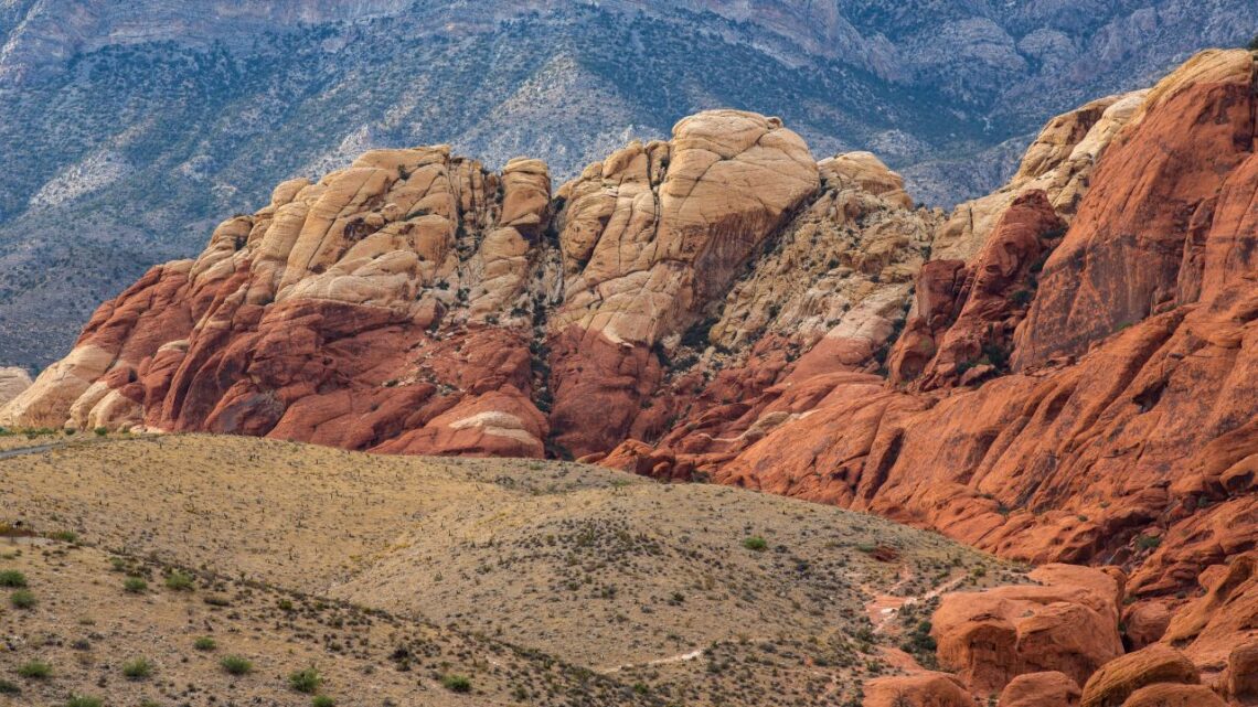
Red Rock Canyon has been around for millions of years, its red sandstone providing a stunning backdrop for the Mojave Desert. And it’s no surprise why many consider this natural wonder an outdoor enthusiast’s paradise. It provides various recreational activities, from rock climbing to camping and hiking. Let’s look at the history and the landscape that makes this place so special.
A Brief History of Red Rock Canyon
Red Rock Canyon is located on the outskirts of Las Vegas and is part of the Mojave Desert Conservation Area. It was formed over thousands and thousands of years of erosion and sedimentation when Earth’s tectonic plates shifted, creating what we know today as Red Rock Canyon.
This geological phenomenon is another reason people flock to this area – to witness its unique geological story firsthand!
The Popularity of Hiking in Red Rock Canyon
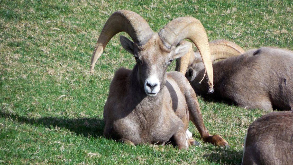
With steep hillsides, winding trails, and miles upon miles of desert terrain, it’s no wonder why hiking in Red Rock Canyon has become so popular among outdoor enthusiasts. It offers spectacular views of the surrounding area and excellent opportunities for wildlife viewing, such as bighorn sheep and mule deer.
Many hikers also enjoy exploring the various trails that meander through the canyon walls with their friends or family. The various trails offer something for everyone, from easy-going family, walks to rigorous mountain ascents.
The Unique Landscape
Red Rock Canyon’s landscape is unique – like no other place in North America! The impressive sandstone walls rise up high overhead while deep canyons cut through them like rivers leading down into hidden valleys below.
The colors range from bright oranges to deep purples, depending on where you are standing, which can create a stunning view at any time during your hike!
The canyon also boasts some interesting rock formations, such as Balanced Rocks and Turtlehead Peak, which provide interesting photo opportunities for any visitor passing through this natural wonderland!
Take a Trip to Red Rock Canyon!
Are you ready for an adventure? Red Rock Canyon is the perfect destination for anyone looking to escape the hustle and bustle of Las Vegas. Located just 17 miles from the city center, it’s easy to get there with several transportation options and plenty of parking. Here’s what you need to know about getting to Red Rock Canyon.
Distance from Las Vegas
Just 17 miles west of the Vegas Strip lies Red Rock Canyon, a stunning desert oasis beckoning those seeking an escape from city life. Explore its stunning sandstone cliffs and canyons along Charleston Boulevard/State Route 159!
Though it may feel like you’re in the middle of nowhere, the canyon is actually quite close to all that Sin City has to offer.
Transportation Options
You can easily reach Red Rock Canyon by car, rideshare, or bike! Take a look at the pricing options to enter the park based on entry methods such as pedestrian, bicycle, motorcycle, car, etc.
Directions and Parking Information
Red Rock Canyon is located 17 miles west of the Las Vegas Strip on Charleston Boulevard/State Route 159.
The best way to experience Red Rock Canyon is by taking the 13-mile one-way scenic drive that features incredible views of desert cliffs, buttes, and spectacular rock formations.
You can also explore the area on foot with hiking and trails or camp in designated areas. The conservation area also offers plenty of opportunities for wildlife viewing and learning about plants and geology.
Explore Red Rock Canyon in Style with Viator’s Tours
Red Rock Canyon State Park is one of the most breathtaking places in Nevada, and Viator has several tour options that will allow you to experience this beauty up close. Whether you’re looking for an intimate private tour or a guided hike into the depths of the Red Rock canyon, Viator has something to offer everyone.
Red Rock Canyon Hiking Tour
A guided hiking tour through Red Rock is available for adventurous people. This 2-2.5 hour hike will take you through some of the most stunning landscapes Red Rock Canyon offers while giving you expert advice from your experienced guide—a great option if you’re looking for something a bit more challenging!
Whether you’re planning a weekend getaway or want some time away from it all, Red Rock Canyon is an amazing outdoor playground right outside Las Vegas’ backyard! Grab your hiking shoes, and let’s take a trip!
Popular Hiking Trails in Las Vegas
Las Vegas is known for its casinos, fine dining, and nightlife, but did you know that it also offers some amazing hiking trails? Read on if you want to explore the great outdoors while visiting Las Vegas. We’ve compiled a list of the most popular trails in the city — Calico Tanks Trail, Bridge Mountain Trail, and Willow Springs Trail—along with an overview of each trail, including length, difficulty level, and highlights.
Calico Basin Trail
Located within Red Rock Canyon State Park in Nevada is a 1.5-mile roundtrip trail that will lead you through a diverse terrain set against an impressive backdrop of red rocks and colorful hills.
This easy-to-follow trail takes visitors along the base of the vibrant Calico Hills where they can take in views of pink, orange, yellow, and grey rock formations. Spotting sport climbers scaling up the walls is not uncommon here as well!
Take your time down this trail as it’s filled with surprises around every corner. Ash trees line parts of the path where you can find seasonal Calico Spring running through its course. It’s quite a sight to see these patches of greenery amidst all those colors!
Keep your eyes open for birds hovering up above as well; many species such as hawks, ravens, and turkey vultures call this area home. Finish this 1.5-mile journey feeling thoroughly rewarded for taking on one of nature’s most beautiful trails – no matter how short it may be!
With its diverse terrain featuring ash trees, rock walls perfect for climbing, plenty of birds soaring in the sky, and incredible views of rocky hills painted with pinks, oranges, yellows, and greys – it’s an adventure you won’t soon forget!
South Oak Creek
If you’re looking for a fun outdoor adventure that is a great challenge, exploring the South Oak Creek hiking trail in Red Rock, Nevada is the perfect activity. Its moderate difficulty level and breathtaking views make for an unforgettable experience.
The South Oak Creek trail stretches 4.8 miles long and takes roughly 3.5 hours to complete. You can access this trail from a dirt pull-out along SR-159 about 1.5 miles south of the Scenic Drive exit. Once you cross the fence and make your way through the open desert toward Oak Creek Canyon, you will be able to appreciate all that this trail has to offer.
Look for petrified wood and conglomerate rock along your journey as you get closer to the hill just before the mouth of Oak Creek Canyon. While making your way up the canyon walls, keep an eye out for bighorn sheep grazing on ledges and eagles soaring above in search of prey.
This trail also provides hikers with spectacular views of Lake Mead and Hoover Dam from atop its summit at about 3100 feet high! As if this amazing view wasn’t enough, when you reach the top of the summit there are lush meadows full of wildflowers waiting to be seen!
Once you reach the end of your journey at South Oak Creek Summit Trailhead, you will have memories that will last a lifetime! Not only do hikers enjoy some well-earned rest while soaking up the scenery, but they also get to appreciate how challenging yet rewarding this hike can be! The beauty and adventure found within these 4.8 miles are truly unique and unforgettable!
Lost Creek | Children’s Discovery
Have you ever wanted to explore the unique, captivating features of the Mojave Desert but feel overwhelmed by all that it has to offer? The Lost Creek Hiking Trail in Red Rock Canyon is perfect for you! This 0.80-mile trail averages 1 hour to complete and has an easy-moderate difficulty level.
It’s a self-guided interpretive trail that introduces visitors of all ages to the wonders of the desert.
The Lost Creek Hiking Trail offers an array of natural and cultural features that can be explored. From towering views, pictographs, and lessons of desert life—you can experience it all here!
One of its most popular attractions is its hidden seasonal waterfall (December-April), located deep in the canyon. Also, hikers can look forward to seeing native plants and animals such as lizards, squirrels, snakes, and coyotes.
This trail provides visitors with stunning views, lessons on desert life, wildlife sightings, and even a hidden waterfall (December-April).
Ash Spring Trail
Located in Red Rock Canyon National Conservation Area, the Ash Spring Trail is an easy 1-mile roundtrip hike with an average time of ½ hour that leads to a lush area full of grass and ash trees!
The trail begins at the Ash Spring Parking Lot and heads west towards the Calico Hills. As you make your way through this tranquil environment, keep your eyes peeled for wildlife that may be enjoying this cool oasis as well! The seasonal spring running through this area provides a great habitat for birds, lizards, and other small creatures.
The beauty of the Ash Spring Trail doesn’t just stop with its wildlife; it also offers amazing views of Red Rock Canyon in all its glory! This trail gives hikers access to incredible overlooks where they can take in majestic views of sandstone rock formations and colorful canyons. You won’t want to forget your camera on this trip!
The beauty of nature awaits at the Ash Spring Trail! This short but sweet 1-mile roundtrip hike takes visitors on an immersive journey into one of Nevada’s hidden gems. From spotting local wildlife to taking in breathtaking views of Red Rock Canyon National Conservation Area, there is something here for everyone.
Calico Tanks
This moderate hike takes around two hours to complete and is perfect for both the beginner hiker and the experienced one looking for a challenge. You’ll be surrounded by incredible rock formations as soon as you step onto the trail.
You’ll pass by red sandstone mountains, limestone peaks, and canyons that will take your breath away. Don’t forget to keep an eye out for desert wildlife as well! From lizards to birds and even wild burros, there is plenty of interesting wildlife in this area that will awe any nature lover.
Plenty of spots offer breathtaking views of the valley below or provide a spot to relax before continuing your journey. These moments make all those hills worth it!
This three-mile loop trail is considered moderate in difficulty and takes about two hours to complete.
Oak Creek Canyon
This 2-mile trek offers breathtaking views and a chance to connect with nature. It’s great for all levels of hikers, from beginners to experienced trekkers. Here’s what you need to know about this incredible trail.
Oak Creek Canyon is a beautiful canyon situated in the Red Rock Escarpment. The hike takes you around the canyon rim, offering stunning views of the surrounding area.
On sunny days, you can see spectacular displays of bluebells, lupines, and penstemons – just some of the native plants that grow here. This is an excellent time for photographers to capture some truly amazing shots!
The Oak Creek Canyon Hiking Trail is 2 miles long and takes about 1 ½ hours to complete (depending on how often you stop). It’s considered easy-moderate in difficulty, so it shouldn’t be too challenging for most people; however, there are some steep inclines and rocky areas, so it’s best to come prepared with appropriate clothing and footwear.
Girl Scout Trail
The Girl Scout Trail lies nestled in the heart of Nevada’s stunning Red Rock Canyon. This 1.3-mile roundtrip is easy to traverse and filled with hidden gems sure to captivate and fascinate any hiker or explorer.
The Girl Scout Trail is as beautiful as it is calming. Hikers will immerse themselves in a unique blend of natural beauty from the surrounding Calico Hills and its vibrant colors to the tranquil sound of nature filling the air.
What sets the Girl Scout Trail apart from other trails within Red Rock Canyon is its close proximity to a picnic area owned by Girl Scouts of Southern Nevada. Here, hikers can take a break from their trek, enjoy lunch, and appreciate all that nature offers.
From its short distance and easy difficulty level, making it perfect for novice explorers, right through to its beautiful surroundings and wonderful wildlife – this trail truly has it all!
First Creek Canyon
It’s a 4-mile trek across a desert valley to a waterfall surrounded by beautiful cottonwood trees, willows, and other shade trees. Plus, this easy-to-moderate trail is well-maintained so you don’t have to worry about getting lost
The First Creek Canyon Hiking Trail is located in Red Rock Canyon National Conservation Area, just 25 miles from Las Vegas. The hike takes an average of two hours, depending on your speed, and stops along the way.
Be aware that the last few feet of the trail are not maintained, and you will need to follow a use trail down the side of the wash to reach the falls.
As you begin your journey through First Creek Canyon, you’ll be met with stunning views of sandstone cliffs and rocky ridges. Along your path, you may spot lizards scurrying away or some wildflowers if it’s been raining recently.
Once you reach the waterfall, you can take a break under one of the cottonwood trees and relax by its cascading waters. Even when there isn’t much water flowing over it, this area makes for an incredibly peaceful place to escape from everyday life for a while!
The First Creek Canyon Hiking Trail is perfect for anyone looking for an enjoyable outdoor experience close to Las Vegas! With its stunning views, interesting wildlife sightings, and peaceful atmosphere at the falls, it’s no wonder why people come back again and again.
Bridge Mountain Trail
Are you looking for an adventure in one of the most beautiful places in Nevada? Then look no further than Bridge Mountain Trail in Red Rock Canyon National Conservation Area.
This popular four-mile out-and-back trail takes about two hours to complete and offers spectacular views from atop Bridge Mountain Summit at 5,420 feet above sea level.
The trailhead is located at the end of Moenkopi Road, just off Highway 159. From there, it’s mostly uphill—but don’t worry, it’s a moderate hike that only requires some basic fitness. The path is well-marked, but bring plenty of water and snacks along with you.
Once you reach the top of Bridge Mountain Summit, you will be rewarded with gorgeous 360-degree views of Las Vegas Valley below. On a clear day, you can see all the way to Lake Mead! Don’t forget your camera, as this is definitely one view worth capturing—you won’t find another like it!
Moenkopi Loop:
Looking for an easy yet rewarding exploration of the great outdoors? Look no further than the Moenkopi Loop at Red Rock Canyon! This 2-mile loop is the right distance to enjoy nature’s most beautiful desert views. The best part?
You can get a good overview of this mesmerizing area in only 1.5 hours. Keep reading to learn more about what you can expect from this incredible outing!
Begin your journey at the Visitor Center, and take in all of the beauty that Red Rock Canyon has to offer. As you traverse around this limestone ridge, keep your eyes open for various desert flora and even Triassic fossils!
If you’re up for a bit more exploring, there are connecting trails leading off from the Moenkopi Loop, which will take you into the Calico Hills area (2-mile loop). No matter where you venture off to, prepare yourself for panoramic views of the Wilson Cliffs – a sight that will truly take your breath away.
The terrain is mostly flat with little elevation change and is considered easy by experienced hikers. Plenty of overlooks and benches are scattered along the way, so you can take breaks if needed.
Calico Hills
This trail runs along the base of the Calico Rocks from Calico Basin to Sandstone Quarry. Depending on where you access it, the distance can range from 2-6 miles and generally takes 1.5-3.5 hours to complete. While this trail is considered moderate in difficulty, it’s worth it for the breathtaking views and fun challenge!
The trails along Calico Hill offer great views and some fun obstacles. As you make your way up and down hills and around rockslides, you will get a fantastic view of Red Rock Canyon National Conservation Area and distant mountain ranges, including Mount Charleston and Griffith Peak.
Along with incredible scenery, hikers should also expect some technical terrain, such as boulder fields and sandstone ledges, that add an extra challenge for experienced hikers looking for more than just a leisurely stroll through nature’s beauty.
The easiest way to access this trail is from either of two parking lots—one near Sandstone Quarry or one in Calico Basin. Alternatively, if you don’t want to commit to an entire loop hike but still want to enjoy part of the scenery, there’s also a side trail that runs from the fee booth parking lot that connects with this main loop (2–6 miles).
Whichever route you choose, rest assured that all routes offer spectacular vistas!
Turtlehead Peak
Looking for a challenging hike with an incredible view? Look no further than Turtlehead Peak in Red Rock Canyon. This 4.6-mile hike takes an average of 3.5-4.5 hours to complete, and it is rated as strenuous due to its elevation gain and technical terrain.
But the payoff at the summit is worth every step—you’ll be treated to one of the most stunning panoramic views of Red Rock Canyon! Read on for more details about this amazing hike.
Turtlehead Peak is located in the Mojave Desert outside Las Vegas, Nevada, in the famous Red Rock Canyon Recreation Area. At 8,037 feet above sea level, it requires some serious effort to reach the summit—but those who make it will be rewarded with sweeping views of Red Rock Canyon below them.
Experienced hikers should only attempt this hike with a good fitness level due to its length and elevation gain (2,200 feet). It’s also important to note that this area can get extremely hot during summer; if you’re visiting between April and October, you should plan your trip for early morning or late afternoon when temperatures are cooler.
Windy conditions can also occur year-round—so don’t forget your windbreaker!
The trail begins at the Pine Creek Trailhead near mile marker 15 on State Route 159. It follows a well-marked path up Turtlehead Mountain Ridge that winds through desert shrubs and cacti before reaching an open flat area at the top where you’ll find panoramic views across all of Red Rock Canyon.
The hike down will take between 1-2 hours, depending on how fast you walk; keep an eye out for lizards skittering across your path!
Although this strenuous 4.6-mile trek takes around 3.5-4.5 hours roundtrip, it’s worth every step for experienced hikers who are looking for a challenge with an incredible view as their reward!
Ice Box Canyon
This 2.2-mile trail takes hikers through a shady box canyon with seasonal waterfalls from December to April. But be warned, this trail is considered strenuous due to its rugged terrain and the fact that it requires crossing the open desert to get there.
Once you cross the open desert and start on the trail, prepare for an experience like no other. The canyon rarely sees sunlight, making it significantly cooler than the surrounding areas—a welcome reprieve from the desert heat.
As you make your way down into the canyon, you will come across several pools of cool water and will be able to experience natural phenomena such as seasonal waterfalls (December-April). Once at the canyon’s end, enjoy taking in the views before heading back out.
The hike is considered difficult due to parts of it requiring climbing over boulders and loose rocks within the wash. It’s best to wear shoes with good grip for these sections and bring plenty of water and snacks for energy along with sun protection such as hats or umbrellas.
Additionally, when hiking in a remote area like this one, always remember to leave no trace behind by packing out any garbage or food scraps you might have brought.
Ice Box Canyon is an incredible adventure that should be experienced by avid hikers looking for a challenge in one of nature’s most unique settings! Get ready for an unforgettable journey; remember to take all necessary precautions before embarking on your journey and enjoy!
Keystone Thrust
This 2.4-mile hike has an average completion time of 1.5 hours and is moderately difficult.
The trailhead for the Keystone Thrust Hike is situated in the Sandstone Quarry parking lot, located off Highway 160. When you reach the Sandstone Quarry parking lot, park in the designated area or risk a ticket or a tow!
As you go down the trail, keep an eye out for signs pointing toward the Keystone Thrust. You’ll know when you’ve reached it; look up and behold its grandeur!
As mentioned above, on average, this 2.4-mile hike takes around 1.5 hours to complete. However, if you’re looking to take your time and really explore this magical land, it could take much longer!
You can expect an array of stunning sights as you traverse this ancient land – witness limestone layers rolling over sand dunes as they have done since millions of years ago when tectonic plates collided in what was known as ‘the great shove’ – pushing up the Sierra Nevada mountains on one side and creating Red Rock Canyon on the other!
White Rock Willow Springs
This four-mile loop is rated as “moderate” and takes around 2.5 hours to complete. Let’s break down this incredible trail and discover what makes it so special.
The adventure begins at the upper parking lot at White Rock Spring, located in the Red Rock Canyon National Conservation Area. You will take the trail on the west side from here until it splits with both directions descending downhill.
To your right, you will find a guzzler—a man-made water hole—while taking the left path will lead you through a wash and then up over a ridge before dropping into the Lost Creek area.
This part of the hike can be particularly enjoyable as it showcases some of Nevada’s most beautiful scenery, including breathtaking rock formations, vast desert landscapes, and vibrant wildflowers during springtime.
After winding your way through the Lost Creek area, you will arrive at Willow Springs, approximately two miles from your starting point at White Rock Spring.
From here, you reverse your steps to make your way back over the ridge, through the wash, and down to where the trail splits once again, bringing you back to White Rock Spring after completing four miles of desert exploration!
With its moderate difficulty level, this four-mile loop is great for hikers of all skill levels, making it perfect for anyone looking for a fun outdoor adventure.
Kraft Mountain Loop
Are you looking for a challenge? Look no further than the Kraft Mountain Loop Hiking Trail, nestled in the Calico Basin of Red Rock Canyon National Conservation Area.
This trail is not for the faint of heart; it is a strenuous 3.5-mile loop featuring intense elevation gain and rock scrambling. But with its unique views, colorful wash, and rugged terrain, conquering this trail will be an unforgettable experience.
The hike starts at the end of Sandstone Drive within Calico Basin. Follow the trail around Kraft Mountain as it takes you into a colorful wash—where red and orange hues dominate the landscape as far as your eyes can see.
Make sure to take plenty of water and snacks, as this challenging loop can take between 2.5 and 3 hours to complete depending on your speed.
As you make your way up Kraft Mountain, you’ll be surrounded by rocky cliffs that offer stunning views of Las Vegas Valley—and if you’re lucky enough to catch a glimpse of one of Red Rock’s many species of rare birds or wildlife, you’ll feel like you’ve been transported to another world entirely.
After making your way down the mountainside again, cross over the creek bed and make your way back to where you started!
Gene’s Trail
This 2.6-mile roundtrip hike is perfect for anyone who wants to explore the natural beauty of Calico Basin and take in the breathtaking views of Las Vegas. The trailhead is easily accessible off SR-159, so it’s perfect for a day trip from the city! Let’s explore this hidden gem in more detail.
Gene’s Trail is a moderate hike that travels across the open desert and takes you through the eastern portion of Calico Basin. You’ll gain and decline over 300 feet in elevation, allowing you to take in beautiful views of both Calico Basin and Las Vegas.
Along with these views, keep your eyes peeled for various yucca plants and cacti as you make your way along this trail.
The trail is easy to navigate, with a large black trailhead sign marking its beginning. It eventually merges with Kraft Mountain Loop Trail at the northern end of Calico Basin, which can be used as an alternate route if you choose to make the hike longer than 2.6 miles roundtrip—or even turn it into a full loop! For those looking for a shorter hike, turn around at any point on the trail to head back towards your starting point.
Dale’s
This 4-mile route takes you deep into the Red Rock Escarpment, offering breathtaking views and a moderate difficulty rating. It’s perfect for hikers who want to explore something new and adventurous yet still have time to enjoy the beautiful scenery. Let’s take a look at some of the features that make this trail so special.
This 4-mile route offers something that many other trails in the area don’t—it follows a fairly gentle grade most of the way, but it also has several short, steep sections.
These sections are great for hikers looking for an extra challenge, as they provide an opportunity to test your stamina and strength. Most of the route is relatively flat, however, so there’s plenty of opportunity to explore without having to worry about running out of energy too quickly.
Dale’s Hiking trail is one of the most beautiful routes in this part of Nevada. As you make your way along the base of the escarpment, you can expect to be surrounded by stunning desert landscapes and towering red rocks. The trail takes you through the open desert and offers plenty of opportunities for wildlife spotting.
Birdwatchers will love it here—you can often spot hawks soaring overhead or quail running through the low scrub brush!
Dale’s Red Rock Trail is an excellent choice for hikers who want a unique experience surrounded by natural beauty and challenging terrain features. With its 4-mile length and moderate difficulty rating, it makes for the perfect day hike.
Whether you’re looking for stunning vistas or a chance to test your physical capabilities, Dale’s Red Rock Trail has something for everyone! So grab your hiking gear and head out on this unforgettable journey today!
Middle Oak Creek
The famed Red Rock Canyon in Nevada is one of the most beautiful places in the world. With its red sandstone canyons, towering cliffs, and vibrant desert landscape, it’s no wonder it attracts hikers from all over the globe. But if you’re looking for an unforgettable experience, try the Middle Oak Creek trail.
This 3-mile hike through Oak Creek Canyon will take you through some of the most breathtaking scenery imaginable.
On this moderate-level trek, you’ll start by crossing a fence at a dirt pull-off along SR-159, about 0.6 miles south of the Scenic Drive exit. Follow the open desert trail as it winds through Oak Creek Canyon, and you’ll soon be rewarded with incredible views of the red rock escarpment. You may even spot some wild horses that roam freely in this part of Nevada!
Along your journey, keep an eye out for petroglyphs left behind by Native Americans who used to inhabit this area. These ancient symbols carved into rock walls will make your hike more memorable and special.
As you make your way up Middle Oak Creek Trail, don’t forget to take breaks and enjoy nature’s beauty around you. Look up to admire the stunning cliffs above or look down at colorful wildflowers blooming along the path—this is truly an outdoor adventure like no other!
When you reach your destination at the top of Red Rocks Escarpment, marvel at panoramic views that extend for miles around and capture photos to remember this moment forever!
Calico Overlook
Take a break from the hustle and bustle of everyday life and escape to the majestic wonders of Calico Overlook Trail in Red Rock Canyon, Nevada. This 1.5-mile roundtrip trail is the perfect place to explore the beauty of nature, take in the desert air, and experience a sense of tranquility away from it all.
Situated within Red Rock Canyon National Conservation Area, Calico Overlook Trail is an easy-to-moderate loop trail starting from the Red Spring Picnic Area.
The path takes you up and around the Red Spring Boardwalk and gently down into a sandy wash as you marvel at massive sandstone boulders along your way. This trail does feature some elevation gain & decline but nothing too strenuous for most hikers.
Hike through this serene desert oasis and discover why people have been drawn to its unique beauty since long ago!
Grand Circle Loop
The Grand Circle Loop Redrock Trail is a breathtaking 11.4-mile hike that takes about 6 hours to complete. Though challenging, this scenic trail is worth every step!
With five different starting points and plenty of desert foothills and washes to explore, this trail is the perfect way to spend a day in nature. Let’s take a closer look at what the Grand Circle Loop offers.
The Grand Circle Loop Redrock Trail features a variety of terrain for hikers of all abilities. Beginners can enjoy the easy access trails with little elevation change as they take in the sights of wildlife and wildflowers.
Experienced hikers can tackle the more strenuous sections, which include hills and sandy areas. No matter your skill level, you’ll be able to find something enjoyable on this trail!
The best place to start your journey is from the Visitor Center near Scenic Drive. From there, you can take any one of five routes, some leading up to higher elevations than others.
Each path offers its own unique experience, so feel free to explore them all if time allows! Along your journey, you can spot wildlife like eagles soaring overhead or lizards scurrying across the rocks – keep an eye out for these amazing creatures! You may also come across plants like wildflowers blooming in shades of yellow, orange, and lavender throughout springtime.
Whether you’re a beginner or an experienced hiker looking for a challenge, the Grand Circle Loop Redrock Trail is an incredible way to explore nature at its finest. So grab your hiking gear and get ready for an unforgettable adventure – happy trails!
Knoll Hiking Trail
This 3.6-mile trail takes hikers through a variety of terrain and is sure to be an unforgettable experience!
During your hike, you can expect to encounter a variety of small mammals, deer, bighorn sheep, birds, and lizards. With lush vegetation throughout the area and plenty of cacti and shrubs to admire along the way, this trail has something for everyone!
Along with its incredible scenery and wildlife viewing opportunities, Knoll Trail offers a variety of terrains to explore. From challenging inclines to rocky ridges and smooth patches of sandstone throughout the canyon floor, this trail will keep you on your toes—all while providing spectacular views around every corner!
The average time to complete the hike is 2.5 hours, but it can take longer depending on how often you stop to take in all that nature offers.
Although Knoll Trail is considered moderate in difficulty, there are still some challenging stretches that hikers need to be aware of before setting out on their journey.
There are some steep inclines and small boulders strewn across the ridge that can make navigating difficult terrain difficult—so make sure you bring sturdy shoes or boots with good traction!
White Rock Mountain Loop
Red Rock Canyon is known for its beautiful sandstone formations and majestic views. But there’s one hidden gem you should check out if you’re looking for an adventurous day trip – the White Rock Mountain hike.
This strenuous 6.2-mile loop takes you through a secluded pocket of life around the colorful sandstone mountains. You’ll traverse through several different habitats and gain & decline nearly 1,000 ft in elevation.
This trail offers stunning views of the surrounding area, including a large mesa that overlooks the canyon floor below. You’ll also pass through several habitats, including pine forests, juniper trees, and cactus fields. There are also several scenic spots where you can take a break and soak in the beauty of nature.
The trail is rated as strenuous due to its steep inclines and declines in elevation. It typically takes 3-4 hours to complete depending on your pace and how long you choose to rest along the way.
Willow Spring Loop
Nevada’s Red Rock Canyon is a popular destination for visitors, but many don’t know about the Willow Spring loop hike. At only 1.1 miles long, this trail is a great way to experience the beauty of Red Rock on a short and easy hike – perfect for families or beginners! Here’s what you need to know before you go.
The Willow Spring loop is 1.1 miles long with an average time of 1.25 hours, making it an accessible adventure for hikers of all ages and skill levels.
The trail begins at the Willow Springs parking lot, where you will pass by two historical sites – a pictograph site and agave roasting pits – before reaching the Lost Creek parking lot.
Take the right fork along the paved path back to the starting point at the Willow Springs parking lot.
Hikers will enjoy breathtaking views of limestone cliffs, sheer rock walls, and red sandstone formations in every direction along this easygoing path. You may spot some local wildlife, like bighorn sheep or wild burros, along your journey!
So grab your camera and bring plenty of water — it’s time to explore one of Nevada’s most beautiful natural wonders on the easy-going Willow Springs Loop Trail!
La Madre Spring
This trail takes you on a 3.6-mile journey and has an average time of two hours. Plus, it’s rated as a moderate-difficulty hike, so it’s perfect for those seeking an exciting challenge without being too intense. Let’s take a closer look at what you can expect when you embark on this incredible adventure!
Meander through the canyon’s contrasting landscapes – red and white sandstone cliffs meet gray limestone mountains for a breathtaking adventure.
Embark on an exciting journey up this old road to uncover its hidden wonders! Nestled deep in a rugged canyon lies an unexpected forest, lush with pinyon pine, vibrant juniper, and the typical western scrub oak. Revelers can explore this hidden wooded haven that is bursting with life!
As you make your way up the canyon path, keep an eye out for wildlife that may be drinking from La Madre Spring. The contrast between the desert environment and this spring will surely refresh you as you take in all its beauty.
At the end of your hike lies La Madre Spring—a site that will reward you with stunning views and provide water to animals in this area. This spring has been part of many stories throughout history and continues to captivate visitors today, thanks to its unique beauty. So don’t forget to bring your camera along!
With fascinating wildlife sightings around every corner, breathtaking red rocks towering across the horizon, and lush vegetation surrounding the trail—you won’t regret taking part in this amazing journey!
Pine Creek Canyon
Explore the Pine Creek Canyon Trail in Red Rock, Nevada, for an easy and rewarding hike. This 2.4-mile moderately difficult trail offers a variety of landscapes, from the lush ponderosa pine forest at the mouth of the canyon to the impressive monolithic canyon walls that rise up above it.
You can expect to spend around two hours on this trail – just enough time to take in all its beauty without feeling rushed.
As you make your way through Pine Creek Canyon, you’ll find yourself surrounded by diverse plant communities, some of which are remnants from the last Ice Age!
The air is cool and filled with the sound of water flowing down Pine Creek, making for a tranquil experience. In addition to enjoying nature’s beauty, hikers can observe a variety of wildlife, including mule deer, rabbits, and more!
The trail is well-marked and maintained and provides plenty of places to rest along its route. The terrain ranges from flat areas to boulder-strewn sections as well as steep inclines – but don’t worry – nothing too strenuous!
The views from the top are breathtaking; you can overlook miles of stunning desert landscape dotted with colorful sandstone formations.
If you’re looking for a short but sweet outdoor adventure, look no further than Pine Creek Canyon Trail in Red Rock Canyon. After two hours of exploring, you’ll get unbeatable views and feel like you’ve returned in time!
Fire Ecology
You can take a short hike along the 0.4-mile loop trail into Pine Creek Wash. It’s an easy hike that takes about 1 hour to complete and offers insight into how prescribed burns can help reduce the risk of catastrophic wildfires. Read on to learn more!
The Bureau of Land Management performed a prescribed burn in 1992 to clear brush and reduce the chances of a catastrophic wildfire killing off tall ponderosa pines in the wash.
As you walk along this 0.4-mile loop, you’ll be able to see evidence of this effort. Little remains from the fire itself, but it’s clear that their efforts have been successful so far in reducing fire risks for these trees and other vegetation surrounding them.
In addition to learning about fire ecology, visitors will also have the chance to observe wildlife, such as birds, chipmunks, rabbits, and squirrels.
Other trails are nearby for visitors who want to extend their exploration or take a longer round trip of 0.9 miles through the conservation area.
Petroglyph Wall
Red Rock Canyon National Conservation Area is an awe-inspiring experience for visitors of all ages. Located just outside Las Vegas, this area provides stunning natural beauty and a glimpse into the past with its ancient petroglyphs. The Petroglyph Wall Trail is a great place to start for those looking to explore these unique artifacts.
The Petroglyph Wall Trail is a 0.4-mile out-and-back trail that takes you across a wash and towards a cliff-side featuring thousands of petroglyphs estimated to be 800 years old or more.
The petroglyphs are mostly found on the cliffs in the area, so take your time examining them as you go along. When you come upon the wall, look for symbols such as animals, plants, people, and geometric designs carved into the rock by ancient cultures.
The carvings, created by members of the Paiute and Shoshone tribes, tell stories about life in this area over centuries. Each image has its own meaning; some believed to symbolize fertility, while others depict hunting scenes or human figures with arms raised in prayer or celebration. While deciphering the exact meanings of each design can be tricky (especially given their age), they offer us a fascinating insight into how life was lived in this part of Nevada centuries ago.
The Petroglyph Wall Trail at Red Rock Canyon National Conservation Area is a great way to explore this unique place and get a glimpse into history. From exploring these ancient carvings to taking in breathtaking views of the canyon, there’s something for everyone on this short but memorable hike.
North Peak Trail
The North Peak Red Rock trail at Red Rock Canyon is one of the more strenuous mountain trails, and it’s perfect for those seeking a breathtaking experience.
Starting at the Willow Spring Picnic Area, this hike takes you through a pinyon-juniper forest and brings you to the top of the Red Rock Escarpment. Read on to discover what makes this trail unique and why it should be at the top of your list!
The North Peak Red Rock trail is 11.8 miles long and has an average completion time of 5 hours. It’s rated as moderately strenuous, and portions of this trail are unmarked and require scrambling over rocks and up steep inclines.
As you make your way through this rugged terrain on foot or by bike (for experienced bikers only!), there’s no shortage of sights to take in along the way.
From lush green meadows to majestic rock formations rising from the ground like monoliths from another time—there’s something special about this area that you won’t find anywhere else.
Be sure to plan ahead before embarking on this journey by gathering all necessary supplies beforehand—and don’t forget your camera!
Arnight Hiking Trail
This 2.2-mile trail is perfect for hikers of all levels and offers stunning views of the wild desert landscape. Let’s take a closer look at this amazing trail and how to get the most out of your visit!
The Arnight Trail is an easy-to-moderate hike that takes about 1.5 hours to complete. The trail winds through an open desert along the base of Wilson Cliffs, with lots of low-growing shrubs, yucca, cholla, and brittlebrush.
As you climb the bajada at a slight grade, take in stunning views of red rock formations along one side and wide open desert on the other. Keep an eye out for small washes as you make your way up the trail; if there has been recent rainfall, you may see some running water!
Many birders come to explore this area because there are many different species. Look out for roadrunners, quail, owls, hawks, horned larks, and more! If you want to spot them all while on your hike, bring a pair of binoculars to get a better view from a distance. You may even spot some other wildlife, like jackrabbits or coyotes!
What to Bring
Red Rock Canyon is a beautiful destination to explore and appreciate nature. To make the most of your trip, pack essentials such as hats, water for hydration, sunscreen for protection from harsh sunlight in arid climates, and some snacks to fuel up on the go!
Adventurers need to be aware of the risks associated with traversing this majestic landscape when hiking at Red Rock Canyon in Nevada.
From hot summer temperatures that can make exertion difficult to wildlife encounters and changing terrain conditions – hikers should come prepared and attentive while navigating one of nature’s true marvels!
Red Rock Canyon is a stunningly beautiful place – and its popularity amongst hikers shows no signs of slowing down! From the rocky outcrops that line wild trails to panoramic views across twisted canyons, it’s an incredible experience. Whether you’re planning your first trek or are already familiar with this area, take some time to explore – Red Rock will leave you in awe each step of the way!
As an Amazon Associate, I earn from qualifying purchases. Some links on this site are affiliate links. Portions of this content are generated by AI.

You must be logged in to post a comment.